March 03, 2026
Catalyst’s Paul Duddle ready to join national debate as Subsidence Forum chairman
Catalyst Services UK Operations Director Paul Duddle is looking forward to being a key...
This is Part 3 of a three-part guide to subsidence, drawing on the expertise of Catalyst teams in undertaking subsidence site investigations, drainage investigations, and subsidence monitoring – especially for insurance claims clients and their customers.
Here, we explain how damage caused by subsidence can be repaired, what action can be taken to prevent subsidence from occurring and the insurance claims response to subsidence events. We also look at future responses to subsidence, including technical innovations.
Our Subsidence Service Guide Part 1 provides an overview of what subsidence is (and what it is not), the general terms that define it, its causes and how it can be detected. In Part 2, we explain how subsidence investigations are carried out, the range of techniques used to establish if subsidence is occurring, and what causes it.
What is the sequence of actions needed to tackle subsidence?
There are a number of key steps an experienced subsidence specialist will take:
Investigation – All possible factors affecting the condition of the structure will be considered and, where necessary, investigated;
Mitigation – If necessary, mitigation measures will be taken to prevent further damage to the property;
Monitoring – A period of monitoring is likely to be needed to establish how the subsidence is affecting the structure over time;
Remediation – When the impact of the subsidence and its development is fully understood, the best form of remediation can be considered, if appropriate.
Underpinning is the main remediation techniques for protecting buildings at risk from subsidence or found to be affected by it. There are a wide range of underpinning techniques.
Each has different advantages and drawbacks based on factors that include: ground conditions; the structure and strength of the building; and the necessary depth of the new foundations.
Underpinning works in three main ways:
Mass concrete underpinning is one of the most common techniques for correcting subsidence due to its relatively low cost and suitability for shallow depth underpinning. It can also cope with heavy loads.
The ground below sections of the foundations is excavated in stages, known as pins, down to weight-bearing ground. Each pin is filled with concrete in turn, with the load transferred by packing dry sand-cement mortar between each pin and the old foundations.
With mini pile underpinning, thin piles are driven or augured down to levels where the ground is stable enough to support a building. The process needs specialist equipment and greater technical precision than mass concrete underpinning. The technique is useful for working on buildings where access is restricted.
A reinforced concrete beam is installed, most commonly below the existing foundations. The beam rests on an appropriate number of mass concrete bases, designed and located to direct the weight of the building safely down to a firmer subsoil.
This technique involves injecting a resin, combined with a chemical catalysing agent into the ground under a building’s foundations. The resin reacts with the chemical, expanding and hardening, to compact and harden weak soil, so the building is property supported. Key advantages of the technique is that it is easier to apply where space is constrained and it is less disruptive.
| Underpinning methods for shallow foundations | Underpinning methods to support stabilisation of soils | Underpinning methods for deep foundations |
|---|---|---|
| Mass concrete underpinning | Expanding resin injection | Raft pile underpinning |
| Pynford beam underpinning | Cement grouting | Needle beam pile underpinning |
| Needle beam underpinning | Jet grouting | Cantilever beam pile underpinning |
| Cantilever needle beam underpinning | Chemical grouting | Jacked piling |
| Jacking underpinning | Compaction grouting | Push pier underpinning |
| Helical pier underpinning | ||
| Mini pile underpinning |

There are a number of factors that increase a property’s risk of subsidence, including:
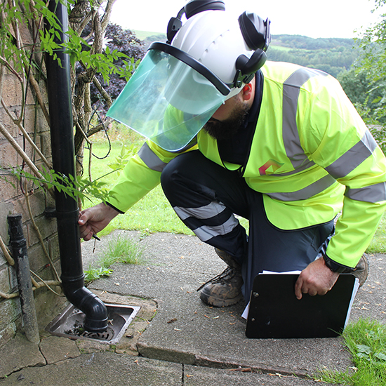
The British Geological Survey has published maps showing the areas with the highest subsidence risk in the UK due to soil conditions. These allow you to see if your property is located in a risk area.
However, the only way to assess with any degree of accuracy if your property is at risk is to commission a subsidence services specialist to carry out a subsidence survey.
It would also be sensible to check if your property insurance covers subsidence risk and, if it is not, take steps to make sure it has the appropriate type and level of cover.
Before buying a property in an area known to have a higher risk of subsidence, or a property that has been affected by subsidence, it would be advisable to take a number of key actions. These are likely to include:
Insurance policies for homes or other properties do not always automatically cover subsidence. In some cases, it is offered as an add-on policy enhancement that incurs a higher fee.
Due to the often higher costs of subsidence investigations and remediation work, excess payments for subsidence claims are often higher. Other specific conditions, service limits and exclusions may also apply to subsidence cover.
It is important that the property owner has a clear understanding of what their buildings insurances covers, what it does not, and what financial conditions are in place with regards subsidence cover.
It may pay to take out a buildings insurance policy with an insurance company that specialises in providing subsidence cover, or taking out additional cover, over and above your standard buildings insurance policy, with such a specialist insurer.

How a subsidence insurance claim is processed will depend, to a degree, on the terms of the cover provided. In essence, though, the first task will be to investigate the cause and extent of damage caused and to establish if it is caused by subsidence.
The insurer is likely to commission a subsidence specialist to carry out this investigation. The specialist will provide the insurer with recommendations for next steps, which could include:
At any point in this process, it may be necessary for the policy holder and their family to move to temporary accommodation if:
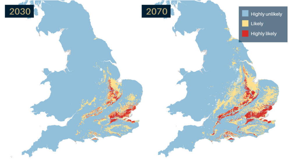
Research carried out by the British Geological Survey (BSG) indicates that climate change will result in millions more homes in the UK being put at increased risk of subsidence.
It mapped the UK’s geology against predicted climate change and found that, due to higher summer temperatures, clay formations across the south east of England will become more susceptible to shrinkage, which is the primary cause of subsidence.
In a medium risk scenario for predicted weather changes, the area of Great Britain that is highly or extremely likely to see increased risk of clay-related subsidence increases by a third from 2020 to 2030 and by 300% by 2050.

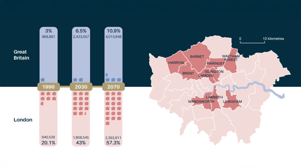
Around a million homes were at risk of subsidence in 1990, according to the BSG. This rises to 2.4 million in 2030 and 4 million in 2070. London is the worst affected area, with nearly half of the capital’s homes at increased risk in 2030 and 57% in 2070.
The key areas affected are London, Essex, Kent, and a swathe of land from Oxford up to the Wash on the east coast of England. The London boroughs most likely to have increased subsidence risk according to the BGS are Camden, Islington, Brent, Barnet, Harrow, Haringey, Waltham Forest, Wandsworth, Lambeth and Lewisham.

Homes at risk from subsidence: BSG
Technology for investigating subsidence, protecting buildings against it, and carrying out remediation when it occurs is developing all the time.
Perhaps the two most exciting and far-reaching areas of innovation are artificial intelligence (AI) and satellite monitoring – and the way both will be combined.
These are the kinds of exciting developments being explored right now by members of the Subsidence Forum, an organisation where subsidence experts and insurance providers work together to address this thorny issue.
As with other industries and technical processes, AI has the potential to revolutionise the way subsidence is investigated.
It is already beginning to enhance the efficiency and improve the accuracy of measuring systems and predictive capabilities.
AI will be used increasingly to analyse large and complex subsidence data sets, and build more accurate and dynamic predictive models of where and when it will occur.
These models will be increasingly used by insurance providers to help them set premiums and assess the best way to respond to claims made by their customers.
AI will also enhance our ability to carry out real time remote monitoring, for example using satellites (see below), reducing the need for site inspections and providing continuous updates on ground movement.
This streamlining of the investigation process, and the ability to obtain more accurate and usable information from data, will make our response to subsidence risks faster and more cost-effective.
AI will also allow better and more powerful integration of technologies, including automated survey drones, GIS mapping, building sensors, and satellite sensors to build a more accurate picture of subsidence and factors influencing it, including climate change.

Satellites have been used for 20 years or more to detect and monitor subsidence.
In the next decade their use is likely to greatly accelerate as the cost of development and launching satellites comes down, sensing technology improves and AI makes rapid and detailed analysis of vast amounts of data possible for the first time.
An important monitoring technique related to subsidence detection, monitoring and investigation is satellite-based radar interferometry (InSAR).
It works by taking two images of the same area at different times. The images are compared, and the phase difference in the radar waves can be analysed to detect ground movement.
Key applications of the technology include detecting subsidence caused by groundwater extraction, mining, or natural geological processes, plus monitoring urban infrastructure and foundations for gradual sinking.
GPS data from satellites is used to the precise ground movement in specific locations – identifying changes in land features and allowing visible signs of subsidence, like sinkholes, to be accurately mapped.
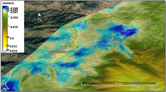
Satellites can provide data on environmental and human activities that contribute to subsidence, such as: groundwater extraction, urban development, and industrial activities, like mining.
Historical satellite data is used to build predictive models, helping scientists and engineers forecast future subsidence events. This helps assess long-term impacts of subsidence on infrastructure and natural ecosystems.
If you need advice about the causes of subsidence and what to do about it, talk to the experts at Catalyst Services UK today.
Helping business and domestic customers every day of the year

March 03, 2026
Catalyst’s Paul Duddle ready to join national debate as Subsidence Forum chairman
Catalyst Services UK Operations Director Paul Duddle is looking forward to being a key...
February 12, 2026
Extreme weather is the new normal – this is what it means for drainage maintenance
Prolonged rainfall this winter is a sign of a pattern of weather we must...
January 28, 2026
Community giving will continue in 2026, says Catalyst boss
Catalyst Services UK has pledged to continue to support charities, voluntary organisations and people...